Producing accurate track plans from photos - practical?

Discuss the prototype and how to model it.
User avatar
John Donnelly
Web Team
Posts: 1092
Joined: Fri Mar 16, 2012 7:03 pm

Producing accurate track plans from photos - practical?

Postby John Donnelly » Fri Aug 31, 2012 5:26 pm

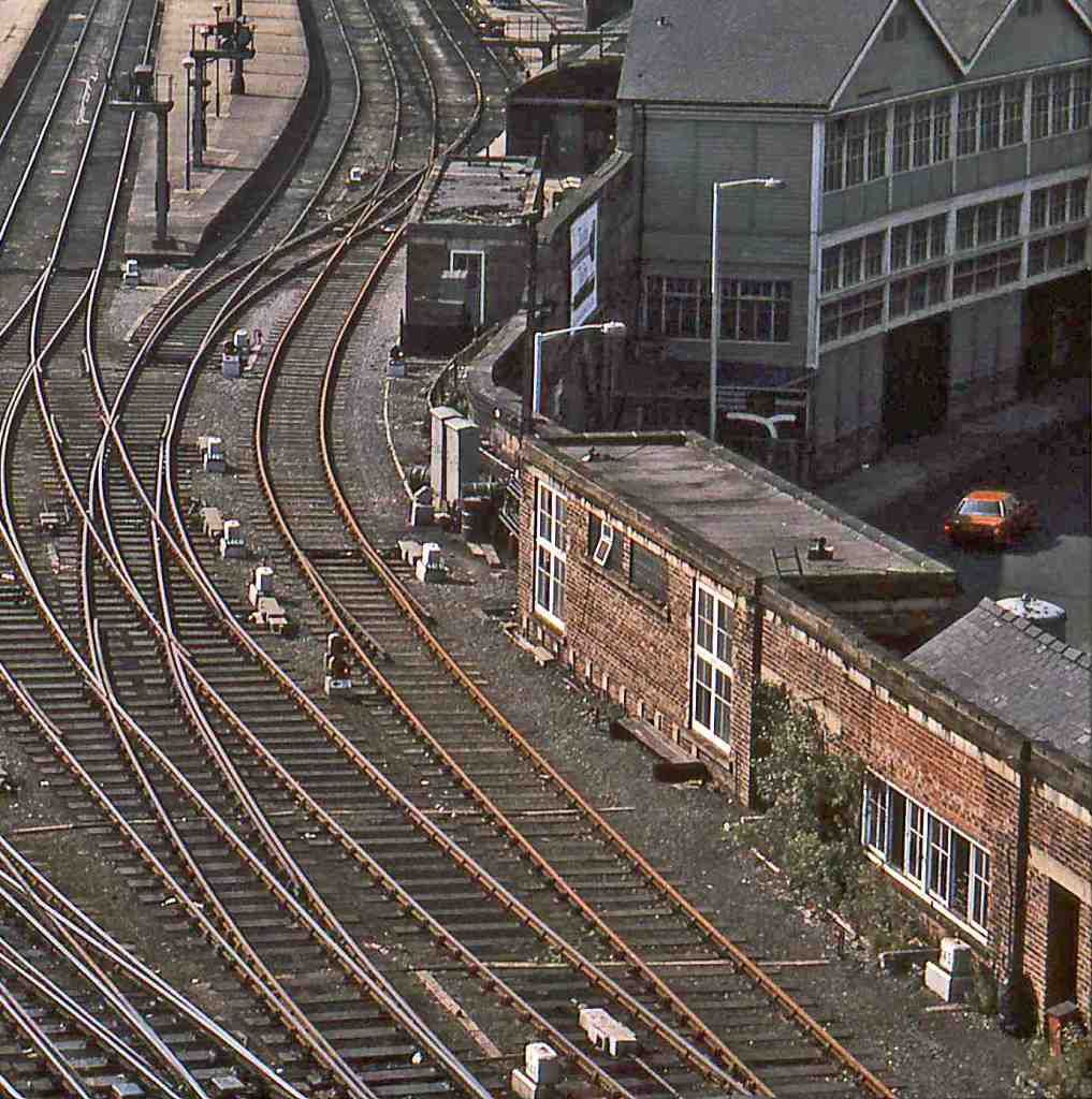
When planning a layout of an actual location, is it feasible to produce an accurate track plan just from photos?

Take the following pic of the east end of Newcastle Central Station for example

Image

Ultimately, I will use Templot (once I have learnt how to use it) but, even with that, the only way I can see of producing a track plan is with a huge amount of trial and error to get everything to fit correctly or does any one have a cunning plan for this sort of thing?

John

allanferguson
Posts: 389
Joined: Sun Jul 20, 2008 6:27 pm

Re: Producing accurate track plans from photos - practical?

Postby allanferguson » Fri Aug 31, 2012 5:36 pm

Well, there is a cunning plan -- a lot of trial and error! Some sort of scale plan is helpful, for getting overall dimensions -- large scale OS plans, for example. There is some discussion on the Templot Forum about using Gimp to eliminate perspective from photos (I don't understand it, but others do....). But to find whether a particular crossing is 1:10 or 1:12 you're going to have to try it out. Good fun, but time consuming!

Allan F

User avatar
grovenor-2685
Forum Team
Posts: 3923
Joined: Sun Jun 29, 2008 8:02 pm

Re: Producing accurate track plans from photos - practical?

Postby grovenor-2685 » Fri Aug 31, 2012 5:46 pm

Indeed there is, or was, a step by step guide to doing just that using the Gimp, I doubt if Martin has removed it, try searching for Gimp on the Templot site.
Regards
Keith
Regards
Keith
Grovenor Sidings

User avatar
jim s-w
Posts: 2190
Joined: Wed Jul 30, 2008 5:56 pm

Re: Producing accurate track plans from photos - practical?

Postby jim s-w » Fri Aug 31, 2012 6:02 pm

Hi John

can you use google earth and then work out the bits that are different? The planning portal is useful too.

Cheers

Jim
Jim Smith-Wright

http://www.p4newstreet.com

Over thinking often leads to under doing!

User avatar
John Donnelly
Web Team
Posts: 1092
Joined: Fri Mar 16, 2012 7:03 pm

Re: Producing accurate track plans from photos - practical?

Postby John Donnelly » Fri Aug 31, 2012 6:47 pm

Thanks gents, I'll check out the Templot forums for Gimp.

Jim, unfortunately, most of the track you see in the pic is now a car park so Google Earth, whilst is has proved very useful for overall widths and lengths is no use for the track plan.

Looks like it's going to be a big job...

John

User avatar
Russ Elliott
Posts: 930
Joined: Thu Jun 02, 2011 6:38 pm

Re: Producing accurate track plans from photos - practical?

Postby Russ Elliott » Fri Aug 31, 2012 7:47 pm

Maybe an old OS map would be a useful start. They're notoriously wrong on turnout lead lengths, but will give the overall shape and size (and presumably useful as a Templot 'background shape'), after which the process of counting timbers and jiggling in Templot can commence.

andrewnummelin
Posts: 374
Joined: Mon Jul 21, 2008 9:43 am

Re: Producing accurate track plans from photos - practical?

Postby andrewnummelin » Fri Aug 31, 2012 8:06 pm

For the Templot info see
http://www.templot.com/martweb/info_fil ... _track.htm

I've not used the technique on track work, but I have with wagons - well worth the effort of learning how to do it.
Regards,

Andrew Nummelin

User avatar
steamraiser
Posts: 561
Joined: Thu Dec 31, 2009 4:49 pm

Re: Producing accurate track plans from photos - practical?

Postby steamraiser » Fri Aug 31, 2012 11:47 pm

Have you tried asking English Heritage at Swindon if they have an aerial photographs for your area of interest and period?

They have the R A F's collection of historical aerial photographs of the UK.

Gordon A
Bristol

User avatar
Martin Wynne
Posts: 1172
Joined: Mon May 14, 2012 4:27 pm

Re: Producing accurate track plans from photos - practical?

Postby Martin Wynne » Fri Aug 31, 2012 11:47 pm

My track-gimping page is also at:

http://templot.com/companion/index.html ... _track.htm

The GIMP pages are actually the most viewed on the Templot web site. They have remained unchanged for 10 years and are due for an update.

You might find The GIMP a strange program to use. It scatters itself across the screen in several separate windows which have an annoying habit of hiding themselves behind each other while you are working. I find that I am constantly having to click them back from the task bar.

If you are looking at the image window, first click the Dialogues > Tool Options menu item. On that dialog window click the Perspective tool icon:

Image

Now click on the image. The grid should appear, and also the Perspective dialog window containing the Transform button. (There is a lot of additional functionality available by right-clicking on the image.)

regards,

Martin.
40+ years developing Templot. Enjoy using Templot? Join Templot Club. Be a Templot supporter.

User avatar
John Bateson
Posts: 809
Joined: Wed Jul 02, 2008 6:39 pm

Re: Producing accurate track plans from photos - practical?

Postby John Bateson » Sat Sep 01, 2012 6:05 am

Slaving away still on GCR stuff ...

User avatar
randallb
Posts: 35
Joined: Sat Dec 06, 2008 4:39 pm

Re: Producing accurate track plans from photos - practical?

Postby randallb » Sat Sep 01, 2012 10:11 am

John,

If you have the RR Darsley books 'Newcstle to Hexham' and 'Darlington to Newcastle' there are reasonable quality plans - the latter book being the better IMHO.

It is also a 25:1mile so can be readily scanned and imported into templot to have the track superimposed onto it as you go.

I have found these books and this method very satisfactory from a planning perspective - and now only have to build Durham Station - plus viaduct / Hexham Station with NBR junction / Alston .......

:D
Randall

Armchair Modeller

Re: Producing accurate track plans from photos - practical?

Postby Armchair Modeller » Sat Sep 01, 2012 10:36 am

lastofthe-mohicans2.jpg


From an old era, but possibly of use?

User avatar
John Donnelly
Web Team
Posts: 1092
Joined: Fri Mar 16, 2012 7:03 pm

Re: Producing accurate track plans from photos - practical?

Postby John Donnelly » Sat Sep 01, 2012 11:52 am

randallb wrote:If you have the RR Darsley book 'Darlington to Newcastle' there are reasonable quality plans - the latter book being the better IMHO.


Funny you should say that, I just ordered it from Amazon last night :)

John

User avatar
John Donnelly
Web Team
Posts: 1092
Joined: Fri Mar 16, 2012 7:03 pm

Re: Producing accurate track plans from photos - practical?

Postby John Donnelly » Wed Sep 05, 2012 6:20 pm

Thanks again to all who replied. RobM has come up with a cunning plan that I shall be trying out along with all the other suggestions...

John


Return to “Track and Turnouts”

Who is online

Users browsing this forum: No registered users and 0 guests